See John Butler’s sketch in real life
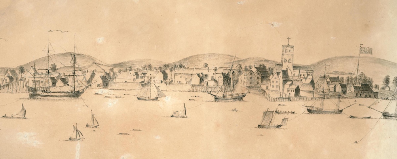
To coincide with the re-opening of Shoreham’s Marlipins Museum this May 2022 it is worthwhile mentioning that a visit to the first floor gallery will give a rare opportunity to view in person the original sketch made by Butler in 1786. This accurate snapshot of Shoreham is especially revealing. Roger Bateman’s meticulous examination and research is linked below.
Marlipins re-opens
After a very long time closed, the Marlipins Museum re-opens on 5th May 2022.
Entry is now free.
This is also an opportunity to re-watch Roger’s superb montage video about the origins of the museum.
Steps of St Marys tower and roof
The Long and Winding Steps
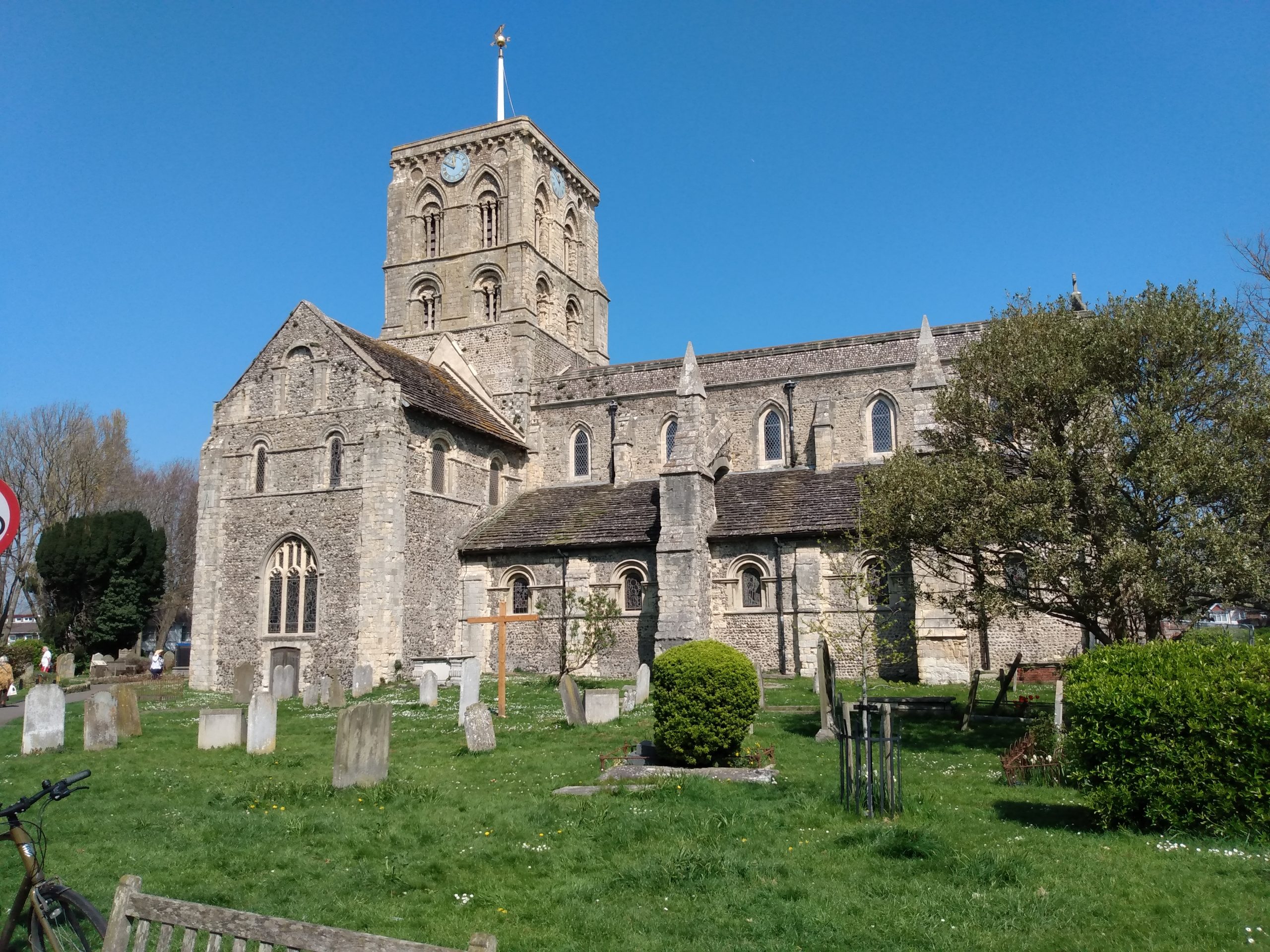
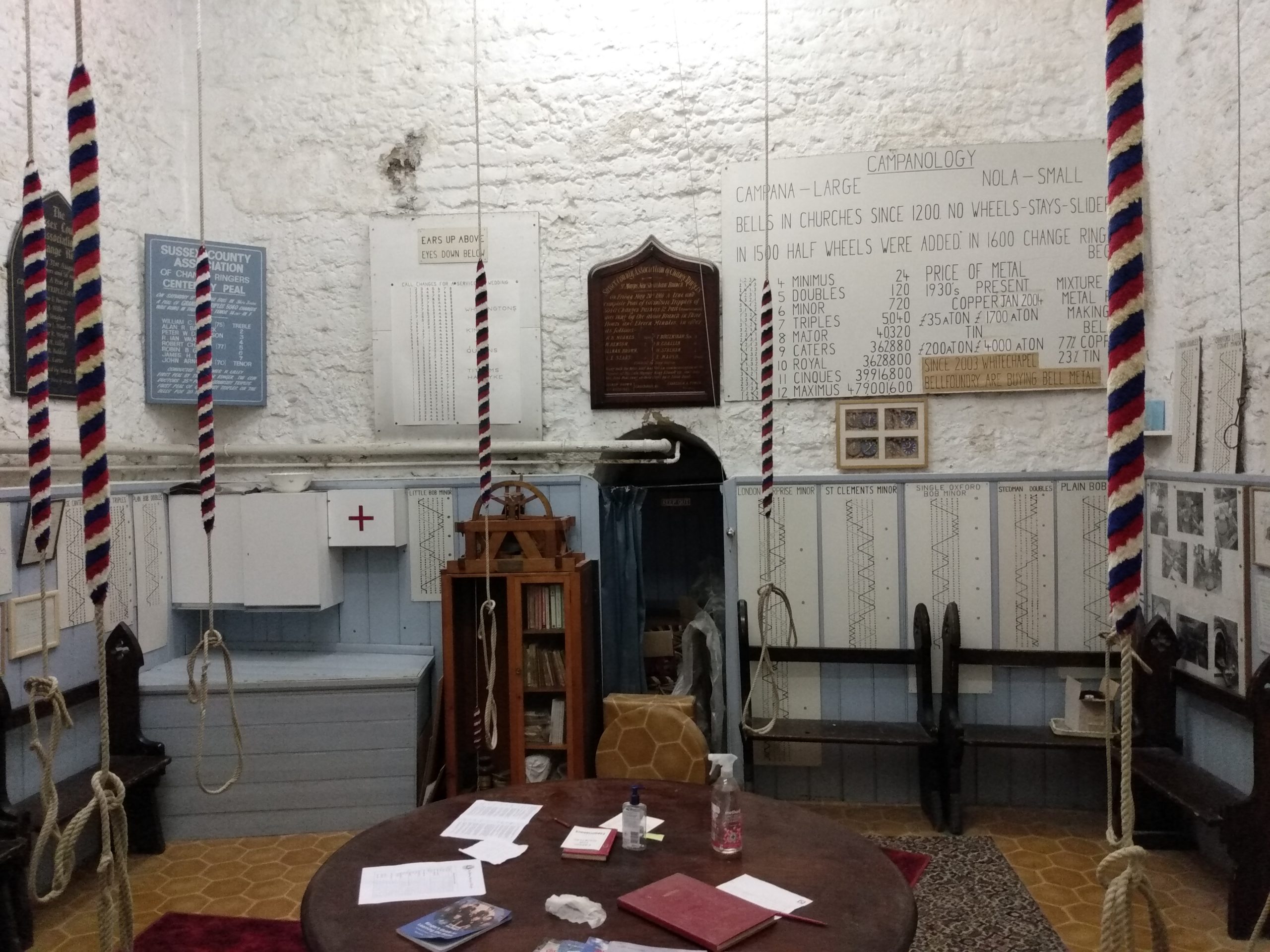
Shoreham’s church of St Mary De Haura has been a landmark for many centuries. For over 250 years the bells suspended in the tower belfry have been rung from the Ringing Room many feet below. The belfry, the ringing room, the clock movement and the tower roof are only accessible via a very narrow spiral staircase in the North East corner of the tower.
Hamish McKenzie is the current St. Mary’s Bellringer’s Tower Captain – and one of his additional roles for many years is to ascend the narrow steps to raise the flag on national days and state occasions. www.Shorehambysea.com were granted access to accompany Hamish to the roof to raise the flag of St. George to mark St. George’s Day 2022.
Continue reading “The Long and Winding Steps”The Rescue – Shoreham in the 1960’s
The Bells of St. Mary’s
On Palm Sunday 2022, Mike Riddiford recorded the Bell Ringing before the Service and later recorded a fascinating interview with Ian Vaughan from the St. Mary’s Bell Ringers in the Churchyard. The recording starts with the sound from the inside Ringing Room, where you will hear Ian calling the bells and then later the Tower Captain Hamish leading the bell ringers.
The St. Mary de Haura Bellringers are keen to encourage new ringers to join them. Bell Ringing uses number notation, so it is not necessary to have any musical knowledge, although a sense of rhythm and a good memory can be helpful. Once the basics have been mastered, ringing becomes a group activity with the opportunity of visiting other towers and making new friends.
http://www.stmarydehaura.org.uk/church-life/bellringers/
Marlipins Gallery 17 (Aerial Photographs)

Marlipins Gallery 17 (Aerial Photographs)
A gallery of Aerial images from the Sussex Archaeological Society’s Collection held at the Marlipins Museum in Shoreham. Should you require copies of any particular images these are available on request from [email protected]
Expand the image by clicking the thumbnail. To see the thumbnail image in full screen, Control+click, and then zoom.

Elevated view from tower of St Mary's Church, Shoreham-by-Sea, looking south across the River Adur to Bungalow Town (now Shoreham Beach) with footbridge (opened 1921) in centre. In foreground is East Street leading down to the bridge with toll booth at north end. House in left foreground, Stow's boat yard to the left of the bridge. River Adur in midground. In background Bungalow Town and the sea. Dated: between 1921 and 1925


Aerial view of the River Adur and part of Shoreham-by-Sea, taken by early aviator Cecil Pashley from a Farman Longhorn" derivative. Wing strut of plane visible in foreground River Adur on left with Norfolk suspension bridge and railway bridge in background buildings of New Shoreham on right including the Catholic Church in centre. Cluster of boats on river in foreground and crowd gathered on shore indicate it is possibly regatta day." Date: pre 1921


c1925-1934

River Adur and Norfolk Bridge, Shoreham-by-Sea. View from the footbridge looking northwest with River Adur in foreground, houses buildings and telegraph poles along bank on right, Norfolk Bridge in background.

Aerial view over Shoreham-by-Sea looking north west with River Adur in foreground and South Downs with Chanctonbury Ring in distant background. Footbridge visible in foreground, railway bridge on left and old toll bridge in middleground with Lancing College and Chapel to its left. Catholic church in foreground centre left, St Mary de Haura centre right with Shoreham Grammar school in Pond Road behind the tower of St Mary's. River Adur winding through fields into distance. Date: after 1934 - demolition of Dolphin chambers but no Coronation Green. Connaught Avenue complete.

Aerial view over Shoreham-by-Sea looking north west with River Adur in foreground winding through fields towards South Downs in distant background. Norfolk suspension bridge in left foreground with railway bridge behind and old toll bridge in middleground with Lancing College and Chapel to its left. Catholic church in foreground centre left, St Mary de Haura centre right. Nurseries to the right of the river between railway bridge and toll bridge, army camp far right middleground. Printed on back This is a Real Photograph from an Avro Aeroplane". Photograph taken summer 1919 by AW Wardell"

Elevated view from tower of St Mary's Church, Shoreham-by-Sea, looking south across the River Adur to Bungalow Town (now Shoreham Beach). In foreground houses, sign for E.H. Curd Builder & Contractor, chimney of shipyard smithy (Stow's Yard) (centre), Butts boat yard on right. River Adur at low tide in midground. In background Bungalow Town with Ferry Road (centre) with three cars.

Elevated view from tower of St Mary's Church, Shoreham-by-Sea, looking south across the River Adur to Bungalow Town (now Shoreham Beach) with footbridge on right. In foreground houses, sign for E.H. Curd Builder & Contractor, chimney shipyard smithy (Stow's Yard) (centre), Butts boat yard on right. River Adur at low tide in midground. In background Bungalow Town with Ferry Road (centre) with three cars.

Shoreham Grammar School, Shoreham-by-Sea. Panoramic view of Shoreham, taken from the tower of St. Mary de Haura church. Swiss Gardens are on the far right. River Adur is on the left. Lancing College is in the distance. Pre-1915

Aerial photograph of Shoreham Chemical Works which produced tarmac for road surfacing at Shoreham Harbour, Shoreham-by-Sea. Also showing the Shoreham - Brighton main coastal road (A259) and the train tracks just visible (top left). Tar works on North side of river, on A259. Sunken concrete barge, used as storage tank, can be seen parallel to the road. Chemical works was on South side. opposite the tar/ creosote yard on the North side of the river.

Aerial view of Kingston and Southwick, looking north-west over harbour and fields. In foreground is the sea and eastern end of Shoreham Harbour with Southwick docks and locks on the right, part of the harbour entrance and partially-built Mystery Towers on the left. Buildings of Southwick, including the church of St Michael and all Angels, on the right behind the docks. Army camp on Slonk Hill in centre mid-background, part of River Adur in left background.

Aerial view of the harbour showing Kingston, Kingston Lane and residential streets. One 'mystery tower' ( later demolished on site, the missing tower was renamed Nab Tower) remains on the River Adur, and was later broken up. The Nab tower was towed away - the outline where it was built can still be seen to the west of the one seen. Course of the railway siding, built to import materials, can be seen at the bottom.


Aerial view of Shoreham harbour entrance where River Adur meets the sea, showing the east and west piers, entrance to Southwick canal, beach and bungalows at 'Bungalow Town'.

Aerial view of the harbour entrance showing where the River Adur meets the sea and entrance to Southwick canal. Also shows bungalows on Shoreham beach, the old fort (built 1857) and the east, west and inner breakwaters (or harbour arms).

Aerial view of Southwick showing beach, canal with boats, canal lock, residential streets and houses. Also visible is the Shoreham - Brighton coast road (A259), railway lines, Southwick Green (top left) and Southwick House amidst trees (top right).

Aerial view of River Adur and Shoreham-by-Sea town partially obscured by low cloud and wing strut of plane. Footbridge to Shoreham Beach in left middle ground, with Norfolk girder bridge (constructed 1923) and railway bridge further north. Boathouse and slipway on north side of river centre foreground.

RAF Aerial Shoreham Harbour. Shows plots cleared of structures to West of Ferry Road

Norfolk Bridge and Shoreham-by-Sea. c1915 Elevated view (taken from the top of St. Mary's Church tower) across the town to Norfolk Bridge to the chain-link suspension bridge over the River Adur (built 1832 and demolished in the early 1920s). Houses and buildings in the foreground including St Peter's Catholic church, bridge and river in middle ground, road on far side leading past Shoreham Airport field in distance.

Elevated view of Shoreham-by-Sea, looking east taken from the tower of the Church of St Mary de Haura. Methodist church is centre left, Ham Road runs east from far left with Ham Road School above the telegraph pole. St Wilfrids. River Adur in far right background.

View of Shoreham-by-Sea from the tower of St Mary's church. Norfolk bridge and the River Adur are in the distance. Railway bridge is on the right. Shoreham Airport is beyond. St Peters's Catholic church is in the middle distance. Middle Street Hall is in the foreground. Photo number 5036. Reprinted by R. Hill.

View across Shoreham-by-Sea looking north west from the tower of St Mary de Haura parish church. In foreground are Shoreham College grounds. River Adur and Lancing College Chapel in background. Hebe Pub. Note Victoria Road School has replaced the Swiss so this dates it as post 1915 but West St. houses not built so pre 1927


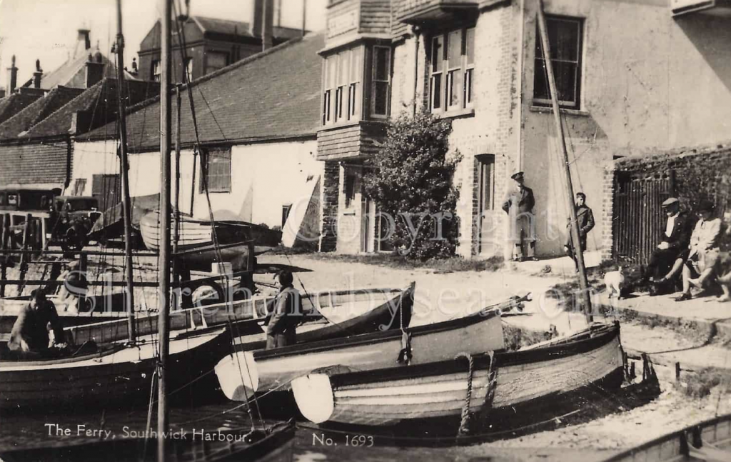
Gill Wright – the ferryman saved my life!
Shoreham Beach resident Gill Wright kindly allowed us to record some of her memories of when she lived in “Town” (West Street) and then when her parents moved to the “Posh part” (Old Fort Road). The lack of transport to Southwick from the east end of the Beach at the time, was resolved when a friend introduced her to “The Ferryman”.
Recorded in interview with Mike Riddiford in 2022. The recording is around 14 minutes.
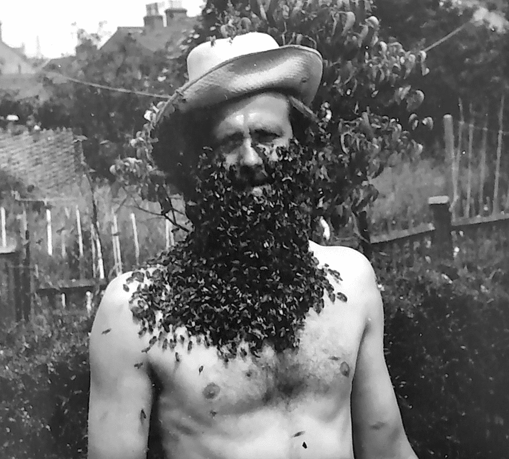
Bill Gebbett – a life with bees
Long time Shoreham resident Bill Gebbett kindly allowed us to record some of his reminiscences from a diverse life in Sussex ranging from his exploits on the farm at Holmbush, driving tractors at 12 years old, becoming a bee expert, amateur film-making, and earning his living as a roofing contractor. Recorded in interview with Mike Riddiford in 2022. The recording is around 47 minutes.